


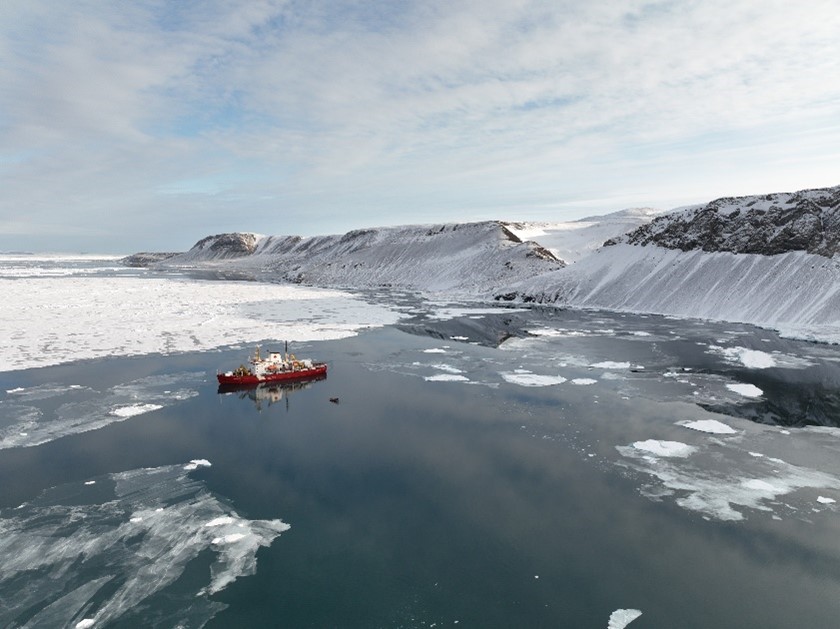
The CCGS Amundsen in Archer Fjord during September 2023. Archer Fjord has never been previously visited by a scientific expedition. Photo by Amundsen Science.
Deploying four moorings in the High Arctic
CEOS researchers are reaching historic high latitudes aboard the CCGS Amundsen in an effort to understand climate change's effect on water and sea-ice dynamics.
The Canadian high Arctic is a remote region that is not often visited by scientists.
While it can be challenging to reach the high Arctic, it is even more difficult to access the high Arctic oceans due to almost year-round sea ice cover.
The presence of multiyear sea ice makes the area almost inaccessible for most research ships and scientists can only rely on few vessels that are equipped for the environment.
One of these vessels is Canada’s only research icebreaker, the CCGS Amundsen.
Using its capability, oceanographers at the University of Manitoba’s Center for Earth Observation Science (CEOS) are hoping to collect a unique dataset on water dynamics and ice-ocean-glacier interaction and their response to climate change.
This Fall, two CEOS employees from UM – Sergei Kirillov, research associate, and Emma Ausen, technician – took part in the 2023 Amundsen Science Expedition. Together with the Coast Guard crew, they deployed scientific moorings that will remain underwater for two years to collect a continuous record of local oceanographic conditions.
The collection of a comparative oceanographic dataset can be used for climate models and increased understanding of environmental changes in a system where icebergs, ocean currents, fjords and glaciers interact.
How it works
Oceanographic moorings usually consist of a series of instruments that are strapped to a line of rope and anchored to the sea floor. The top of the mooring is a float or a buoy that keeps the line of instruments upright, with the float typically being ~50 m below the water line so that it is safe from icebergs and waves.
The bottom of the mooring is equipped with an acoustic release, which is an instrument that can release the mooring from the ocean floor when an acoustic signal has been received by the device. After the acoustic release has been activated, the buoys will bring the instruments to the surface where they can be recovered.
Instruments on moorings typically measure variables such as the temperature and salinity of the water, as well as water currents, sediment in the water column and ice thickness above. When a mooring is deployed, it is typically left in place for 1-2 years with sensors collecting data at regular intervals.
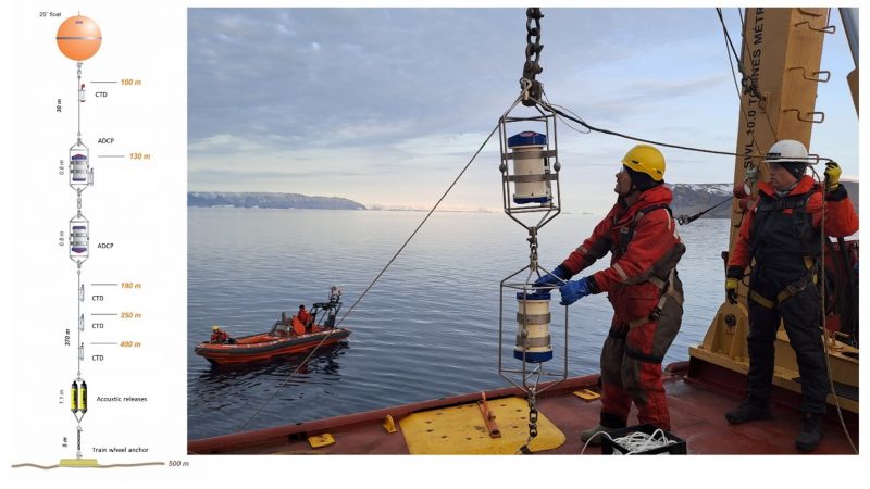
Diagram of a mooring including the anchor, acoustic release, ADCP sensors, CTD sensors and float (left). Deploying this mooring off the CCGS Amundsen (right, photo Emma Ausen).
The CEOS researchers participated in Leg 3 of the Amundsen Science 2023 expedition.
Deployment of the moorings
During the month of September, a total of 10 moorings were deployed by the team, with four moorings planned and designed by CEOS researchers. Two of these moorings were deployed in Lancaster Sound and will be used to compare current oceanographic conditions to those recorded over 20 years ago through moorings from the Department of Fisheries and Oceans.
The moorings were deployed at opposite ends of Lancaster Sound in order to record two different currents: the inflow of the warm intermediate waters from Baffin Bay along the northern coast and the southern outflow. Lancaster Sound is the site of Tallurutiup Imanga National Marine Conservation Area.
Two other moorings were deployed off the western coast of Greenland, at sites that have unique oceanographic conditions. One mooring was deployed near Cape Jackson, which is where the northernmost sensible heat polynya in the world forms every winter.
Polynas – a biological hotspot in Arctic winter
A polynya is an area of open water surrounded by ice, that can serve as a biological hot spot during the Arctic winter. A sensible heat polynya is formed through the upward transport of heat from the deeper ocean which prevents sea ice from forming.
This polynya forms in connection with the Nares Strait Ice Bridge, which is a natural frozen pathway created by solid ice that allows for the movement of people and animals across Nares Strait during winter months.
The polynya being investigated through the Cape Jackson mooring has been suggested to impact the breakup of the Nares Strait ice bridge, which plays an essential role in the formation of Pikialasorsuaq or the North Water polynya, an area recognized for its biological activity and importance to Inuit peoples.
Deploying the Cape Jackson mooring was challenging due to the presence of multiple icebergs from the nearby Humboldt glacier, which required careful vessel navigation during mooring deployal.
With this unique mooring, CEOS researchers are hoping to understand what causes the formation of the polynya during winter and understand how it may respond to further climate change.
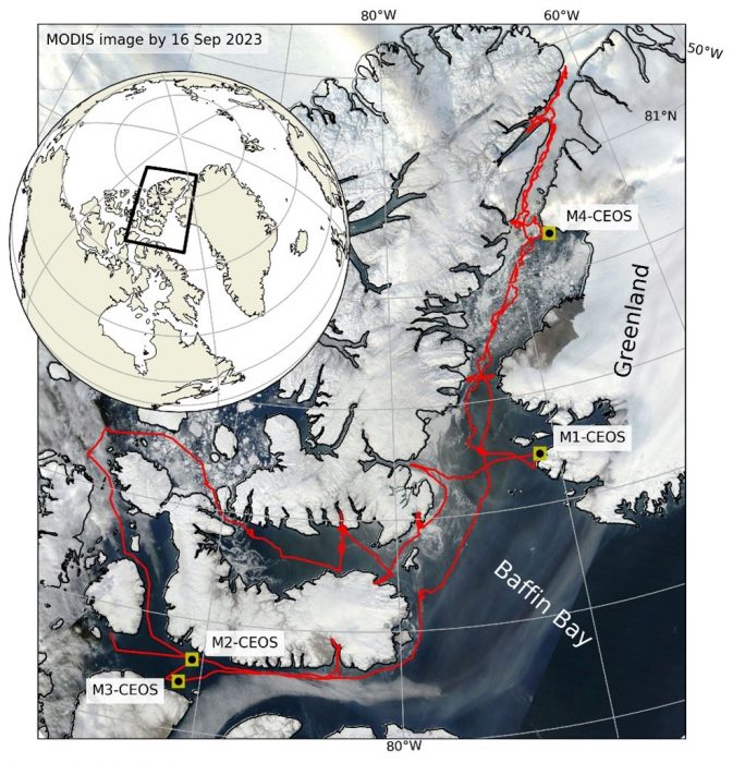
Location of the four moorings deployed around Greenland and Devon Island. Map created by Sergei Kirillov.
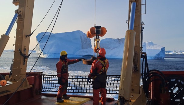
Deployal of a mooring in the coastal waters near Cape Jackson, Greenland. Photo Emma Ausen.
Now that the moorings have been deployed, CEOS researchers can only wait in anticipation for next years expedition when they will return for retrieval. Datasets that are collected on these moorings will contribute to the groundbreaking research of Canada Excellence Research Chair in Arctic Ice, Freshwater Marine Coupling and Climate change led by Dr. Dorthe Dahl-Jensen from the University of Manitoba.
Watch the deployment of one mooring in the coastal waters near Cape Jackson, Greenland here: https://youtu.be/qBnD1OKTN2o
References:
Prinsenberg, S., Hamilton, J., Peterson, I., & Pettipas, R. (2009). Observing and interpreting the seasonal variability of the oceanographic fluxes passing through Lancaster Sound of the Canadian Arctic Archipelago. In Influence of climate change on the changing Arctic and Sub-Arctic conditions (pp. 125-143). Springer Netherlands.
https://parks.canada.ca/amnc-nmca/cnamnc-cnnmca/tallurutiup-imanga
http://pikialasorsuaq.org/en/News/Press-release-November-2017