


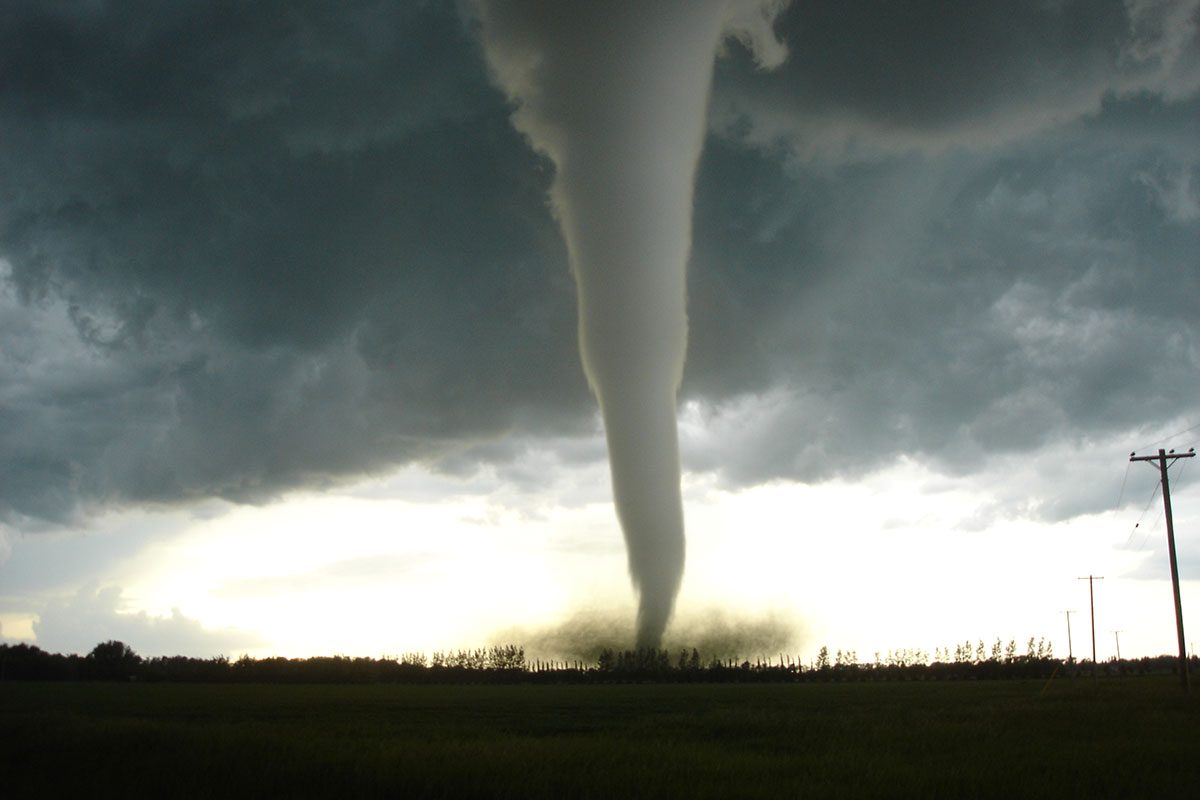
The June 22, 2007 Elie tornado. // Photo from Justin Hobson
An alumnus’ eyewitness account of strongest recorded tornado in Canadian history
Ten years ago, on June 22, 2007, an F5 tornado struck the town of Elie, Manitoba. This was one of the strongest tornados in Canada’s history. Justin Hobson [BScPhG(Maj)/2008, MSc/2012] was a physical geography student in the Clayton H. Riddell Faculty of Environment, Earth, and Resources and he witnessed the tornado. This is his story:
In May 2007, I was hired to work at the Environment Canada weather office as part of the University of Manitoba co-op program. On June 22, 2007 conditions were favourable for severe thunderstorm development over portions of southern Manitoba.
I was excited to go storm chasing after work that day because weather models had hinted at the potential for severe thunderstorms several days in advance.
After leaving work I noticed explosive thunderstorm development northwest of Winnipeg. I arrived at my home in Oak Bluff and grabbed my camera and baseball cap. I then went to my computer to wait for the next radar scan to see if the thunderstorm cell was strengthening; it was, big time.
I took off and drove down Highway 2 towards Starbuck, and then went north through town and then west again towards the north/south highway that connects Elie to Fannystelle. Upon reaching that highway I witnessed a wall cloud; the precursor to tornado development. I then parked on a gravel road one mile south of Elie, placed my camcorder on the roof of my vehicle, hit record and watched.
Within minutes funnel clouds began to develop and dissipate. This occurred several times before a long rope funnel reached toward the ground. My first tornado! I called Environment Canada to report what I was witnessing.
Within minutes, the tornado grew into a large cone shape that almost looked blue from my vantage point. I couldn’t believe what I was seeing. After 10 years of being so passionate about severe thunderstorms and after 2 years of chasing, I had finally seen a tornado.

Justin views the tornado on June 22, 2007. // Photo from Justin Hobson
I vividly remember how calm it was around me. I remember hearing birds chirping, as well as frogs in the nearby ditches. I remember mosquitoes flying around and buzzing in my ear, and I also remember hearing the constant low rumble of thunder to the east of me.
All of this was occurring while the tornado slowly twisted its way across open fields towards the southeast. The tornado grew larger and became dark in appearance. I could hear it now. The only thing that resembles the sound of a tornado is a waterfall at close range. It was as if someone was turning up the volume of this “waterfall” as the tornado crept closer.
The tornado appeared stationary for a brief time before it suddenly began moving to the right (east). Shortly after shifting its track I could hear different sounds as large pieces of debris were being hurled around the circulation. It was now hitting the town.
Lightning started to increase in intensity, so I fled to my car with my camera and continued to document the tornado. Power flashes occurred for a brief moment as the tornado severed power poles while impacting the neighborhood on the west side of town.
The tornado continued to hurl debris which could now be seen very high up into the sky wrapping around the tornado. The tornado was moving to the left now (west) where it grew thinner, and thinner, then suddenly disappeared. I wanted to get out of the area just in case a new tornado developed over my head.
Shingles and insulation began to hit the vehicle and land all around the highway as I pressed north towards town.
As I entered the town from the south, I could see a police car, an ambulance and what looked to be two dated fire trucks heading down a residential street towards the area that was impacted. There were also several local residents rushing to the scene so I stopped and turned around.
The next day I performed a damage survey in Elie with two senior meteorologists from the office. The damage was incredible.
I remember the smell of freshly snapped or debarked trees, top soil, and gasoline from flipped automobiles. After witnessing the damage and video evidence that surfaced two months later, the tornado was officially rated F5. This is the highest rating on the Fujita scale.

Damage from the June 2007 tornado in Elie, Man. // Photo from Justin Hobson
Two years later, I started my M.Sc. degree on this tornado event while training as a new meteorologist in Edmonton with Environment Canada. I completed this degree in 2012 and I now have a full understanding of what occurred that day meteorologically.
Analyzing the pre-storm environment prior to and during a tornado is very important. I feel that witnessing this tornado, its damage, and studying the event has given me a leg-up when it comes to severe thunderstorm forecasting.
This tornado still remains the strongest recorded tornado in Canadian history and it feels amazing to have been a part of something historical.
Watch Justin’s video footage below.